comScore pixel
Ergan Mountain Ski Center snow
Ski Turkey

Ergan Mountain Ski Center 16 Day Snow Forecast

Weather Forecast for Ergan Mountain Ski Center at 2355 m
Issued: 8 am  21 Feb 2026 (local time)

Popular Ergan Mountain Ski Center Pages

New snow in Ergan Mountain Ski Center

16.0cm6in
Wed 25th (PM)
The snow forecast for Ergan Mountain Ski Center is: A dusting of new snow. Freeze-thaw conditions (max 2°C on Sat morning, min -5°C on Sun night). Wind will be generally light.

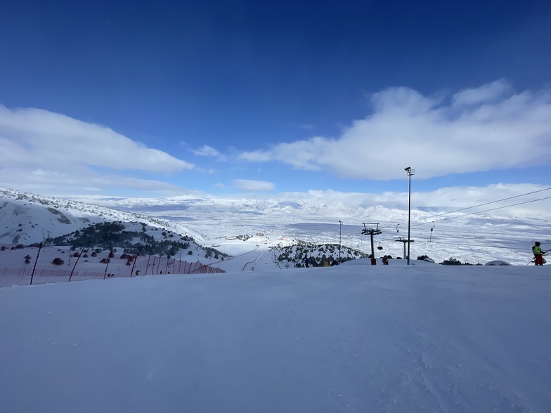
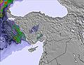
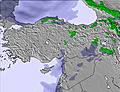
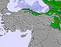
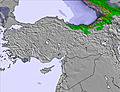
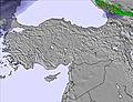
Ergan Mountain Ski Center Weather (Next 3 days): The snow forecast for Ergan Mountain Ski Center is: A dusting of new snow. Freeze-thaw conditions (max 2°C on Sat morning, min -5°C on Sun night). Wind will be generally light.

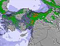
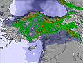
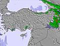
Ergan Mountain Ski Center Weather (Days 3-6): A heavy fall of snow, heaviest during Thu night. Temperatures will be below freezing (max -3°C on Wed morning, min -9°C on Thu night). Wind will be generally light.

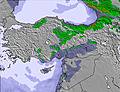
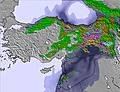
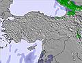
Ergan Mountain Ski Center Weather (Days 6-9): A light covering of new snow, mostly falling on Fri morning. Temperatures will be below freezing (max -5°C on Sun morning, min -10°C on Fri night). Wind will be generally light.

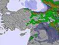
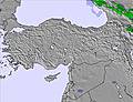
Ergan Mountain Ski Center Weather (Days 9-12): Mostly dry. Temperatures will be below freezing (max -5°C on Mon afternoon, min -9°C on Mon night). Wind will be generally light.

Ergan Mountain Ski Center Weather (Days 12-16): A dusting of new snow. Freeze-thaw conditions (max 1°C on Sat morning, min -5°C on Thu morning). Wind will be generally light.


Ergan Mountain Ski Center Live Weather

ResortSnow DepthTemp. (°C)Wind (km/h)Weather
Top Lift: 
-1
20
clear
Middle Lift: 
2
15
clear
Bottom Lift: 
5
10
clear
Last 6 daysScroll left for last 6 daysNow
Saturday
21
Sunday
22
Monday
23
Tuesday
24
Wednesday
25
Thursday
26
Friday
27
Saturday
28
Sunday
1
Monday
2
Tuesday
3
Wednesday
4
Thursday
5
Friday
6
Saturday
7
Sun
8
AM
PM
night
AM
PM
night
AM
PM
night
AM
PM
night
AM
PM
night
AM
PM
night
AM
PM
night
AM
PM
night
AM
PM
night
AM
PM
night
AM
PM
night
AM
PM
night
AM
PM
night
AM
PM
night
AM
PM
night
AM
PM
clear
clear
snow showers
snow showers
light snow
snow showers
part cloud
snow showers
part cloud
part cloud
snow showers
part cloud
cloud
light snow
heavy snow
mod snow
mod snow
heavy snow
light snow
light snow
light snow
clear
clear
clear
clear
clear
clear
clear
part cloud
clear
clear
clear
part cloud
cloud
cloud
snow showers
part cloud
part cloud
snow showers
part cloud
part cloud
part cloud
cloud
light snow
clear
snow showers
snow showers
clear
clear
snow shwrs
snow shwrs
light snow
snow shwrs
some clouds
snow shwrs
some clouds
some clouds
snow shwrs
some clouds
cloudy
light snow
heavy snow
mod. snow
mod. snow
heavy snow
light snow
light snow
light snow
clear
clear
clear
clear
clear
clear
clear
some clouds
clear
clear
clear
some clouds
cloudy
cloudy
snow shwrs
some clouds
some clouds
snow shwrs
some clouds
some clouds
some clouds
cloudy
light snow
clear
snow shwrs
snow shwrs
 km/h
10
SSE
15
S
15
S
20
S
10
S
5
WSW
0
S
0
SSW
0
S
0
WSW
5
W
10
W
10
SW
15
S
10
S
5
NNE
10
NNE
15
NE
15
NNE
15
N
20
N
15
NNE
10
NNE
5
NNE
5
SSE
5
S
0
S
5
NNW
10
NNW
10
NNW
10
NNW
10
NW
10
NW
10
W
15
W
10
W
10
W
10
W
15
W
15
W
10
WSW
5
SSW
15
SSW
20
S
10
S
10
S
10
W
Snow map
1
15
7
7
19
4
1
1
1
1
max °C
2
2
0
-2
-2
-4
-3
-3
-4
-4
-4
-5
-3
-4
-3
-6
-7
-7
-6
-6
-7
-7
-6
-8
-5
-5
-7
-6
-5
-7
-6
-6
-8
-5
-5
-7
-5
-4
-4
-1
0
0
1
-1
-2
-2
-2
min °C
1
1
-3
-2
-3
-5
-4
-3
-5
-5
-4
-5
-4
-4
-6
-7
-8
-9
-8
-7
-10
-9
-7
-8
-7
-6
-8
-7
-7
-9
-8
-8
-8
-6
-6
-7
-6
-4
-5
-2
0
-1
0
-1
-3
-2
-2
-2
-3
-8
-7
-7
-5
-4
-3
-5
-5
-6
-9
-8
-9
-8
-10
-14
-16
-14
-14
-18
-16
-10
-11
-7
-6
-8
-7
-11
-15
-14
-14
-14
-11
-12
-11
-10
-8
-10
-7
-3
-3
-4
-6
-7
-6
-6
22
30
48
85
87
87
89
85
83
84
87
71
68
86
95
94
93
94
93
91
91
84
67
67
62
67
61
63
62
73
53
44
37
43
57
86
85
78
88
84
77
59
59
94
85
86
89
2750
2750
2050
1950
2050
1600
1650
2000
1550
1600
1900
1350
1550
1850
1800
1350
1300
950
1050
1450
850
700
1350
350
700
1400
550
700
1450
700
750
1350
400
700
1450
900
1100
1650
1150
1600
2250
1550
2500
2150
1800
2000
2050
Sea lvl1000m2000m3000m4000m5000m
0-2-4-7-7-8-8-7-9-9-9-9-8-8-8-11-12-12-11-11-12-12-10-9-8-8-9-9-9-10-10-10-8-7-9-9-9-7-6-4-3-1-2-4-5-6-623-121-201-301-4-11-2-3-4-6-4-3-7-6-6-11-6-4-9-5-4-8-6-6-11-5-3-7-3-2-500-322-221
Sunrise
7:07
7:05
7:03
7:01
7:01
7:00
6:58
6:56
6:54
6:54
6:52
6:50
6:48
6:48
6:46
6:45
Sunset
6:04
6:05
6:06
6:07
6:08
6:09
6:10
6:12
6:13
6:14
6:15
6:15
6:16
6:17
6:20
6:21
Popular Ergan Mountain Ski Center Pages

Snow Radar

Latest snow reports near Ergan Mountain Ski Center:

No recent snow reports

No recent snow reports

Ergan Mountain Ski Center Snow Conditions

Top snow depth:
Bottom snow depth:
Fresh snowfall depth:
Last snowfall:19 Feb 2026
Snow AlertsCreate Alert
Other resorts in Turkey are reporting: powder (0) / good piste (0)

Snow-Forecast Partner Offers

Snow History

Week 3 of February has on average:
0.2
Bluebird Powder days
Fresh snow, mostly sunny, light wind.
0.7
Powder days
Fresh snow, limited sun, any wind.
3.1
Bluebird days
Average snow, mostly sunny, light wind.

Snow-Forecast Partner Offers

Photos of Ergan Mountain Ski Center

  • Ergan Ski Center, Ergan Mountain Ski Center
    Ergan Ski Center by Emrah Karakoç
  • Ergan Mountain Ski Center
    Ergan Mountain Ski Center by MEHMET EMRE CANPOLAT
  • Snowboarder, Ergan Mountain Ski Center
    Snowboarder by Emrah Karakoç

Map placeholder
Other resorts in Turkey are reporting: powder (0) / good piste (0)

The above table gives the weather forecast for Ergan Mountain Ski Center at the specific elevation of 2355 m. Our sophisticated weather models allow us to provide snow forecasts for the top, middle and bottom ski stations of Ergan Mountain Ski Center. To access the weather forecasts for the other elevations, use the tab navigation above the table. For a wider view of the weather, check out the Weather Map of Turkey.

Click here to read further information on freezing levels and how we forecast our temperatures.

Visitor Reviews of Ergan Mountain Ski Center

Free Snow-Forecast.com weather widget for your website

Embed the Ergan Mountain Ski Center weather widget on your site for free. It provides a weekly snapshot of snow and rain conditions across all elevations.

Follow the two quick steps to grab your custom code and paste it into your site. Choose between metric or imperial units. Click here to get the code.