comScore pixel
Nevis Range snow
Ski United Kingdom

Nevis Range Snow Forecast

Weather Forecast for Nevis Range at 656 m
Issued: 5 am  21 Feb 2026 (local time)

New snow in Nevis Range

3.0cm1.2in
Sun 22nd (PM)
The snow forecast for Nevis Range is: Heavy rain (total 44.0mm), heaviest during Sat night. Later becoming colder with a dusting of snow on Sun night. Mild temperatures (max 5°C on Mon night, min 2°C on Sat night). Winds decreasing (near gales from the WSW on Sun night, light winds from the SSW by Mon night).

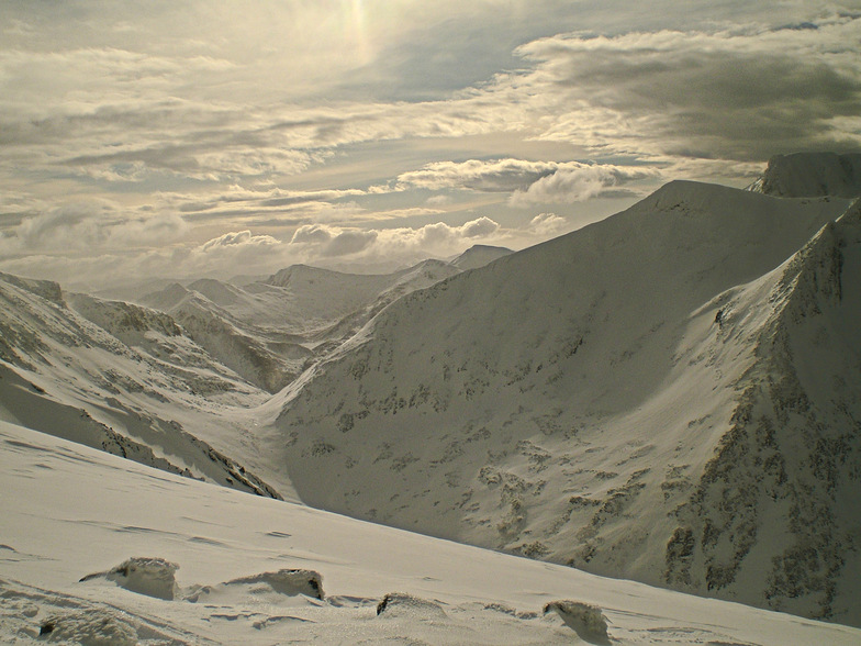
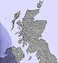
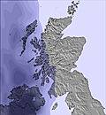
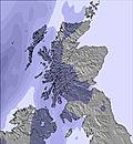
Nevis Range Weather (Next 3 days): The snow forecast for Nevis Range is: Heavy rain (total 44.0mm), heaviest during Sat night. Later becoming colder with a dusting of snow on Sun night. Mild temperatures (max 5°C on Mon night, min 2°C on Sat night). Winds decreasing (near gales from the WSW on Sun night, light winds from the SSW by Mon night).

Nevis Range Weather (Days 4-6): Heavy rain (total 26.0mm), mainly falling Tue afternoon. Becoming colder with a light covering of snow, mostly falling on Thu night. Mild temperatures (max 6°C on Tue afternoon, min 2°C on Wed afternoon). Winds increasing (calm on Wed morning, fresh winds from the WSW by Thu night).


Nevis Range Live Weather

ResortSnow DepthTemp. (°C)Wind (km/h)Weather
Top Lift: 0.2m
2
35
light snow
Middle Lift: 
4
20
light rain
Bottom Lift: 0.15m
5
5
light rain
6 Day Forecast
Issued: 5 am 21 Feb 2026 / Updates in ::
Change Forecast Height
Choose Forecast
Last 6 daysScroll left for last 6 daysNow
Saturday
21
Sunday
22
Monday
23
Tuesday
24
Wednesday
25
Thursday
26
AM
PM
night
AM
PM
night
AM
PM
night
AM
PM
night
AM
PM
night
AM
PM
night
light rain
light rain
rain showers
rain showers
light snow
light snow
light rain
light rain
light rain
light rain
light rain
mod rain
light rain
light rain
light rain
light rain
light snow
light snow
light rain
light rain
rain shwrs
rain shwrs
light snow
light snow
light rain
light rain
light rain
light rain
light rain
mod. rain
light rain
light rain
light rain
light rain
light snow
light snow
 km/h
20
W
20
SW
30
WSW
30
WSW
30
WSW
35
SW
45
W
20
W
15
SSW
20
SSW
30
SSW
30
SW
5
NNE
5
SE
10
S
20
SW
25
SSW
30
WSW
Snow map
1
2
2
5
1
5
9
3
2
14
3
2
5
1
4
7
2
1
5
2
1
3
max °C
4
4
4
3
2
3
3
4
5
5
6
6
4
4
3
3
3
2
min °C
3
3
2
2
2
2
3
3
3
4
5
5
4
2
3
2
2
2
-2
-1
-4
-4
-4
-4
-4
0
0
0
0
0
4
-2
0
-3
-4
-4
92
99
75
89
92
96
91
88
97
98
99
100
98
94
97
99
97
96
1250
1300
1300
1000
950
950
1000
1150
1900
1750
1950
1900
1400
1550
1550
1000
1050
1050
Sea lvl1000m2000m3000m4000m5000m
111-2-2-2-2-12232111-1-1-1556776886778754755
Sunrise
7:33
7:31
7:28
7:26
7:22
7:20
Sunset
5:34
5:36
5:37
5:40
5:43
5:45

Snow Radar

Latest snow reports near Nevis Range:

No recent snow reports

No recent snow reports

Nevis Range Snow Conditions

Top snow depth:20cm
Bottom snow depth:15cm
Fresh snowfall depth:8cm
Last snowfall:20 Feb 2026
Snow AlertsCreate Alert
Other resorts in United Kingdom are reporting: powder (0) / good piste (0)


Snow History

Week 3 of February has on average:
0.2
Bluebird Powder days
Fresh snow, mostly sunny, light wind.
0.7
Powder days
Fresh snow, limited sun, any wind.
0.4
Bluebird days
Average snow, mostly sunny, light wind.

Map placeholder