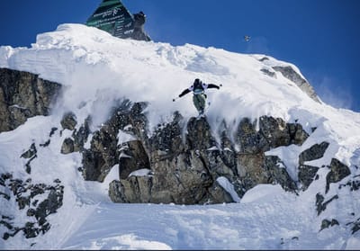
comScore pixel
Jay Peak snow
Ski USA - Vermont

Jay Peak Snow Forecast

Weather Forecast for Jay Peak at 881 m
Issued: 12 am  21 Feb 2026 (local time)

New snow in Jay Peak

9.9cm3.9in
Fri 20th (NGT)
The snow forecast for Jay Peak is: A moderate fall of snow, heaviest on Fri night. Temperatures will be below freezing (max -4°C on Sun morning, min -11°C on Sat night). Winds increasing (light winds from the NW on Fri night, strong winds from the NE by Mon morning).

Jay Peak Weather (Next 3 days): The snow forecast for Jay Peak is: A moderate fall of snow, heaviest on Fri night. Temperatures will be below freezing (max -4°C on Sun morning, min -11°C on Sat night). Winds increasing (light winds from the NW on Fri night, strong winds from the NE by Mon morning).

Jay Peak Weather (Days 4-6): A moderate fall of snow, heaviest on Wed night. Temperatures will be below freezing (max -4°C on Wed night, min -18°C on Tue night). Winds increasing (moderate winds from the WSW on Tue night, strong winds from the WSW by Wed night).


Jay Peak Live Weather

ResortSnow DepthTemp. (°C)Wind (km/h)Weather
Top Lift: 1.5m
-8
10
light snow
Middle Lift: 
-7
5
light snow
Bottom Lift: 0.6m
-7
5
light snow
6 Day Forecast
Issued: 12 am 21 Feb 2026 / Updates in ::
Change Forecast Height
Choose Forecast
Last 6 daysScroll left for last 6 daysNow
Saturday
21
Sunday
22
Monday
23
Tuesday
24
Wednesday
25
night
AM
PM
night
AM
PM
night
AM
PM
night
AM
PM
night
AM
PM
night
mod snow
light snow
clear
clear
cloud
cloud
cloud
light snow
light snow
light snow
light snow
light snow
light snow
light snow
light snow
mod snow
mod. snow
light snow
clear
clear
cloudy
cloudy
cloudy
light snow
light snow
light snow
light snow
light snow
light snow
light snow
light snow
mod. snow
 km/h
20
SSW
10
NNE
10
ENE
15
SE
15
SE
15
SE
35
ESE
40
ENE
40
NE
30
NNW
30
NW
35
W
20
W
25
SSW
25
SSW
50
WSW
Snow map
10
1
2
2
6
max °C
-5
-6
-6
-10
-4
-5
-7
-7
-11
-11
-14
-15
-12
-7
-5
-4
min °C
-7
-7
-9
-11
-6
-6
-8
-8
-11
-14
-14
-17
-18
-9
-6
-9
-10
-11
-15
-17
-12
-12
-18
-18
-22
-25
-24
-29
-29
-18
-14
-19
97
94
47
65
62
81
51
41
95
97
91
91
57
92
94
95
0
0
0
0
0
250
0
0
0
0
0
0
0
0
0
0
Sea lvl1000m2000m3000m4000m5000m
-8-8-8-9-7-7-8-10-13-14-15-18-15-10-7-8-5-5-8-14-3-5-8-7-9-12-13-15-16-8-5-6
Sunrise
6:41
6:39
6:37
6:35
6:33
Sunset
5:24
5:27
5:28
5:29
5:30

Snow Radar

Submit a report Eyeball Reporter

Latest snow reports near Jay Peak:

  • 21 km away from Jay Peak

    25 hours ago
    Eyeball reporter

    The day is shaping up to be very pleasant overall, with sunny spells, mild temperatures, and good skiing. Enjoy! Once again, our mountain operations team groomed several trails last night and finished this morning. The carpet will therefore be very pleasant for beautiful turns. Conditions are variable. You can choose between trails with man-made snow or natural snow, which means the snow texture will be different. It’s interesting. from Mont Sutton

  • 21 km away from Jay Peak

    41 hours ago
    Eyeball reporter

    A very pleasant day with plenty of sunshine and great conditions. Come and enjoy it if you’re on vacation. That’s what’s in store for you this weekend too. This morning, skiers will find many groomed trails to enjoy the joys of skiing and optimize your turns for your greatest pleasure. Have a great run! from Mont Sutton

Jay Peak Snow Conditions

Top snow depth:152cm
Bottom snow depth:61cm
Fresh snowfall depth:
Last snowfall:17 Feb 2026
Snow AlertsCreate Alert
Other resorts in USA - Vermont are reporting: powder (8) / good piste (11)


Snow History

Week 3 of February has on average:
0.8
Bluebird Powder days
Fresh snow, mostly sunny, light wind.
1.8
Powder days
Fresh snow, limited sun, any wind.
1.7
Bluebird days
Average snow, mostly sunny, light wind.

Map placeholder