comScore pixel
Niseko Grand Hirafu snow
Ski Japan - Hokkaido

Niseko Grand Hirafu 16 Day Snow Forecast

Weather Forecast for Niseko Hirafu at 706 m
Issued: 2 pm  21 Feb 2026 (local time)

Popular Niseko Grand Hirafu Pages

New snow in Niseko Grand Hirafu

1.8cm0.7in
Sun 22nd (NGT)
The snow forecast for Niseko Grand Hirafu is: Light rain (total 2.0mm) at first, then becoming colder with a dusting of snow on Sun night. Freeze-thaw conditions (max 5°C on Sun night, min -7°C on Mon night). Winds increasing (light winds from the SSW on Sat night, strong winds from the SSE by Sun night).

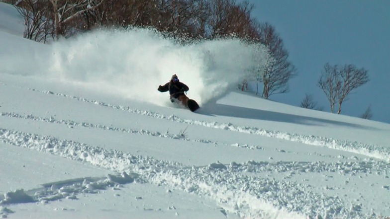
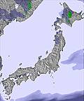
Niseko Grand Hirafu Weather (Next 3 days): The snow forecast for Niseko Grand Hirafu is: Light rain (total 2.0mm) at first, then becoming colder with a dusting of snow on Sun night. Freeze-thaw conditions (max 5°C on Sun night, min -7°C on Mon night). Winds increasing (light winds from the SSW on Sat night, strong winds from the SSE by Sun night).

Niseko Grand Hirafu Weather (Days 3-6): Mostly dry. Freeze-thaw conditions (max 2°C on Fri morning, min -8°C on Tue night). Wind will be generally light.

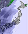
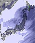
Niseko Grand Hirafu Weather (Days 6-9): A light covering of new snow, mostly falling on Fri night. Freeze-thaw conditions (max 2°C on Fri afternoon, min -3°C on Sun night). Winds increasing (light winds from the ESE on Fri afternoon, strong winds from the N by Sat night).

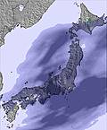
Niseko Grand Hirafu Weather (Days 9-12): A light covering of new snow, mostly falling on Wed afternoon. Temperatures will be below freezing (max -3°C on Tue morning, min -7°C on Wed night). Wind will be generally light.

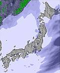
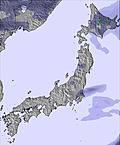
Niseko Grand Hirafu Weather (Days 12-16): A heavy fall of snow, heaviest during Sat afternoon. Temperatures will be below freezing (max 0°C on Fri morning, min -11°C on Sun night). Winds increasing (light winds from the ESE on Thu afternoon, gales from the SW by Fri night).


Niseko Grand Hirafu Live Weather

ResortSnow DepthTemp. (°C)Wind (km/h)Weather
Top Lift: 4.0m
-1
35
clear
Middle Lift: 
0
20
clear
Bottom Lift: 1.5m
0
5
part cloud
Last 6 daysScroll left for last 6 daysNow
Sat
21
Sunday
22
Monday
23
Tuesday
24
Wednesday
25
Thursday
26
Friday
27
Saturday
28
Sunday
1
Monday
2
Tuesday
3
Wednesday
4
Thursday
5
Friday
6
Saturday
7
Sunday
8
PM
night
AM
PM
night
AM
PM
night
AM
PM
night
AM
PM
night
AM
PM
night
AM
PM
night
AM
PM
night
AM
PM
night
AM
PM
night
AM
PM
night
AM
PM
night
AM
PM
night
AM
PM
night
AM
PM
night
AM
PM
night
cloud
part cloud
cloud
cloud
snow showers
snow showers
snow showers
light snow
cloud
cloud
part cloud
clear
clear
part cloud
cloud
cloud
part cloud
cloud
cloud
light snow
light snow
light snow
light snow
cloud
part cloud
part cloud
light snow
light snow
snow showers
cloud
cloud
cloud
light snow
light snow
light snow
light snow
light snow
mod snow
light snow
light snow
heavy snow
mod snow
mod snow
heavy snow
mod snow
light snow
mod snow
cloudy
some clouds
cloudy
cloudy
snow shwrs
snow shwrs
snow shwrs
light snow
cloudy
cloudy
some clouds
clear
clear
some clouds
cloudy
cloudy
some clouds
cloudy
cloudy
light snow
light snow
light snow
light snow
cloudy
some clouds
some clouds
light snow
light snow
snow shwrs
cloudy
cloudy
cloudy
light snow
light snow
light snow
light snow
light snow
mod. snow
light snow
light snow
heavy snow
mod. snow
mod. snow
heavy snow
mod. snow
light snow
mod. snow
 km/h
20
SW
20
SSW
20
SSW
25
S
50
SSE
40
SW
35
WSW
25
WSW
25
WSW
15
WSW
5
WNW
10
NW
10
NNW
5
NW
5
SSW
10
SSW
5
SSW
5
ESE
5
ESE
20
SSE
20
ESE
10
ENE
20
N
35
N
25
N
10
NW
15
NW
15
WNW
15
NW
10
N
5
NNE
5
SSE
10
S
5
SW
5
W
5
W
5
ESE
30
SE
55
SE
30
SSE
50
SW
60
SW
40
NW
45
W
20
WNW
15
NW
10
NNW
Snow map
2
1
1
2
3
3
1
1
1
4
1
7
2
2
11
8
10
13
6
5
8
2
max °C
1
1
3
3
5
-4
-6
-7
-5
-5
-6
-5
-5
-5
0
0
-2
2
2
2
2
1
1
0
1
0
-3
-3
-5
-3
-3
-4
-3
-3
-5
-5
-5
-2
0
-1
-8
-6
-7
-8
-7
-7
-9
min °C
0
0
2
2
-1
-5
-6
-7
-6
-6
-8
-6
-5
-6
-2
-1
-3
0
0
-1
1
1
-1
-1
0
-3
-3
-4
-6
-4
-4
-5
-3
-4
-7
-6
-5
-5
-1
-2
-10
-9
-8
-9
-8
-8
-11
-5
-5
-3
-4
-8
-14
-15
-16
-14
-10
-12
-10
-10
-9
-4
-3
-3
0
-4
-6
-4
-2
-8
-8
-5
-8
-8
-9
-12
-9
-4
-8
-7
-7
-10
-6
-7
-10
-10
-10
-22
-21
-19
-20
-16
-13
-18
85
89
81
76
61
79
79
77
71
54
59
56
62
55
50
47
64
57
53
92
98
99
97
81
63
73
92
92
65
42
37
54
84
96
93
81
76
95
93
93
95
94
95
94
94
90
95
900
850
1300
1650
2050
250
0
0
0
0
0
0
0
0
0
850
0
600
1350
550
1200
1300
1350
400
1700
0
300
300
0
0
0
0
250
250
0
0
150
0
550
500
0
0
0
0
0
0
0
Sea lvl1000m2000m3000m4000m5000m
-2-212-1-9-10-11-10-9-10-9-8-5-2-2-2-11011-1-21-2-6-7-8-6-5-7-6-7-9-10-8-6-4-5-13-11-11-12-11-11-12314330-2-4-1-2-6-2-3-7-10-422011110-110-4-2-2-40-1-4-1-1-221-6-4-4-5-4-5-10
Sunrise
6:24
6:22
6:22
6:20
6:18
6:16
6:15
6:13
6:11
6:11
6:09
6:07
6:05
6:03
6:01
Sunset
5:15
5:15
5:16
5:19
5:20
5:21
5:22
5:23
5:24
5:25
5:28
5:29
5:30
5:30
5:31
5:34
Popular Niseko Grand Hirafu Pages

Snow Radar

Latest snow reports near Niseko Grand Hirafu:

No recent snow reports

No recent snow reports

Niseko Grand Hirafu Snow Conditions

Top snow depth:400cm
Bottom snow depth:150cm
Fresh snowfall depth:
Last snowfall:19 Feb 2026
Snow AlertsCreate Alert
Other resorts in Japan - Hokkaido are reporting: powder (6) / good piste (6)

Snow-Forecast Partner Offers

Snow History

Week 3 of February has on average:
0.7
Bluebird Powder days
Fresh snow, mostly sunny, light wind.
3.6
Powder days
Fresh snow, limited sun, any wind.
0.8
Bluebird days
Average snow, mostly sunny, light wind.

Snow-Forecast Partner Offers

Photos of Niseko Grand Hirafu

  • niseko powder, Niseko Grand Hirafu
    niseko powder by N. M
  • Ice Tree & Youtei, Niseko Grand Hirafu
    Ice Tree & Youtei by powlow
  • So photogenic, Niseko Grand Hirafu
    So photogenic by Snow Forecast Admin

Map placeholder
Other resorts in Japan - Hokkaido are reporting: powder (6) / good piste (6)

The above table gives the weather forecast for Niseko Grand Hirafu at the specific elevation of 706 m. Our sophisticated weather models allow us to provide snow forecasts for the top, middle and bottom ski stations of Niseko Grand Hirafu. To access the weather forecasts for the other elevations, use the tab navigation above the table. For a wider view of the weather, check out the Weather Map of Japan.

Click here to read further information on freezing levels and how we forecast our temperatures.

Resort name is also written as Niseko Hirafu.

Visitor Reviews of Niseko Grand Hirafu

Overall 3.9 Based on 81 votes and 120 reviews

  • Snowsure 4.6
  • Variety of pistes 4.4
  • Vote
  • Nigel Wright from Australia writes:

    Definitely spring skiing conditions now. Only top skiing well atm, but that's becoming heavier too. Freeze thaw, but hey it's still fun and besides, think of all of the many worse things that you could be doing.

Visitor Reviews of Niseko Grand Hirafu

Overall: 3.9 Based on 81 votes and 120 reviews

  • Snowsure 4.6
  • Variety of pistes 4.4
  • Off-piste 4.5
  • Scenery 4.2
  • Apres-Ski 4.0

Nigel Wright from Australia writes:

Definitely spring skiing conditions now. Only top skiing well atm, but that's becoming heavier too. Freeze thaw, but hey it's still fun and besides, think of all of the many worse things that you could be doing.

Read 119 more reviews of Niseko Grand Hirafu or submit your own

Free Snow-Forecast.com weather widget for your website

Embed the Niseko Grand Hirafu weather widget on your site for free. It provides a weekly snapshot of snow and rain conditions across all elevations.

Follow the two quick steps to grab your custom code and paste it into your site. Choose between metric or imperial units. Click here to get the code.

View the full Niseko Grand Hirafu forecast at Snow-Forecast.com